
Arctic death spiral

The Arctic Ocean occupies 14.1 million square kilometers (5.4 million sq mi)  around Earth's North Pole. Historically, most of the surface of the Arctic Ocean stayed ice-covered year-round. Close this core of year-round ice was an edge of seasonal ice that froze each winter and melted each summer. The Arctic ice mass gets its maximum extent in March and its minimum extent in September.

According to a preliminary report from the National Snow and Ice Data Center on September 16, 2021, sea ice cover seemed to get its annual summer minimum. The extent of the Arctic Ocean where sea ice concentration was at least 15% was 4.72 million square kilometers (1.82 million sq mi). That's the twelfth-smallest summer minimum on record and  1.5 million square kilometers (579 thousand sq mi) below the 1981-2010 average.

arcticdeathspiral.org created amazing visualization of how to dissolve ice sheet in the Arctic ocean.
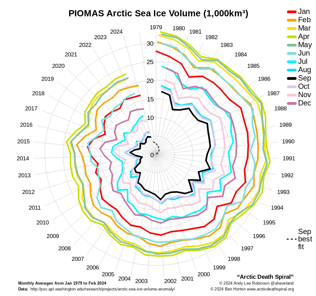
Ice in the Arctic

As Arctic sea ice vanishes, the following feedback effects have already begun and presumably clarify why the Arctic is warming at about twice the global average rate:

- less sunlight is reflected; as a result, the Arctic warms more rapid

- methane locked in the Arctic seabed and neighboring tundra for thousands of years is fleeing: just a tiny fraction of the evaluated deposits would cause 0.5°C of extra warming; a more significant release could lead to a rise of 6-8°C

- more open ocean means more huge waves, slowing and decreasing the formation of the following year's ice

- the sea channels out of the Arctic spend less of the year blocked by ice, letting more ice float away

- shrinking Arctic ice weakens a pivotal driver for ocean currents and restricts the rate at which dissolved CO₂ is pulled into the deep ocean

Even if we prevent further greenhouse gas emissions and stabilize atmospheric CO₂ at present levels, this feedbacks mean Arctic sea ice will continue to retreat, and the global climate will continue to warm.

This post may contain affiliate links. As an Amazon Associate, I earn from qualifying purchases.


Comments

Popular posts from this blog

Find cities with similar climate

This map has been created using The Global environmental stratification. The Global environmental stratification (GEnS), based on statistical clustering of bioclimate data (WorldClim). GEnS, consists of 125 strata, which have been aggregated into 18 global environmental zones (labeled A to R) based on the dendrogram. Interactive map >> Via www.vividmaps.com Related posts: -  Find cities with similar climate 2050 -  How global warming will impact 6000+ cities around the world?

How Cold Can It Get? The Lowest Temperatures Ever Recorded, Mapped

We often talk about record heat , especially in the context of climate change. But on the flip side, our planet also experiences cold so extreme it defies belief—temperatures that can flash-freeze exposed skin and halt life as we know it. These are not just numbers on thermometers; they’re snapshots of how Earth's atmosphere behaves under specific conditions—altitude, wind patterns, and location far from the moderating effects of oceans. The coldest temperature ever recorded on Earth? That title goes to Vostok Station in Antarctica, where scientists measured a bone-cracking −89.2°C (−128.6°F) on July 21, 1983. Located on the East Antarctic Plateau, Vostok is more than 1,000 kilometers from the South Pole and sits atop about 3.7 kilometers (2.3 miles) of ice. It’s isolated, dry, and high—three ingredients that make for perfect deep freeze conditions. The world map below created by VividMaps shows the lowest temperature ever recorded by country. The Coldest Inhabited Place on Earth...

Mapping the Hottest Temperatures Ever Recorded on Earth

 When summer arrives, it brings not only vacation season but also some of the most extreme heat waves across the globe. While many people associate summer with warm, sunny days, some regions endure scorching temperatures that push the limits of human endurance. To put these extremes into perspective, we’ve mapped the highest temperatures ever recorded in countries around the world. The maps below, created by Vivid Maps , illustrate these record-breaking temperatures and the patterns of extreme heat across the globe. The Hottest Temperature on Record According to historical weather data, the highest reliably recorded temperature on Earth is 56.7°C (134°F) , measured in Death Valley, California , on July 10, 1913 . However, an even higher temperature of 58°C (136.4°F) was reportedly recorded in El Azizia, Libya , on September 13, 1922 . While this Libyan record stood for decades, some meteorologists have questioned its accuracy due to inconsistencies in measurement methods at the ti...