Atlantropa was a huge construction and colonization idea produced by the German architect Herman Sörgel in the 1920s.
He intended to connect the continents of Europe and Africa throughout the partial evaporation of the Mediterranean Sea (drain 1/5 of the Mediterranean sea), allowing millions of Europeans to get a new life in what would become the Eurafrican supercontinent (Atlantropa). The new supercontinent would provide food for 150 million people.
The idea was caused by the then-new understanding of the Messinian salinity crisis, a pan-Mediterranean geological event that took place 5- 6 million years ago.
The basin of the Mediterranean Sea is hydrologically deficient, which means that it loses water by evaporation rather than gains by the supplying of rivers.
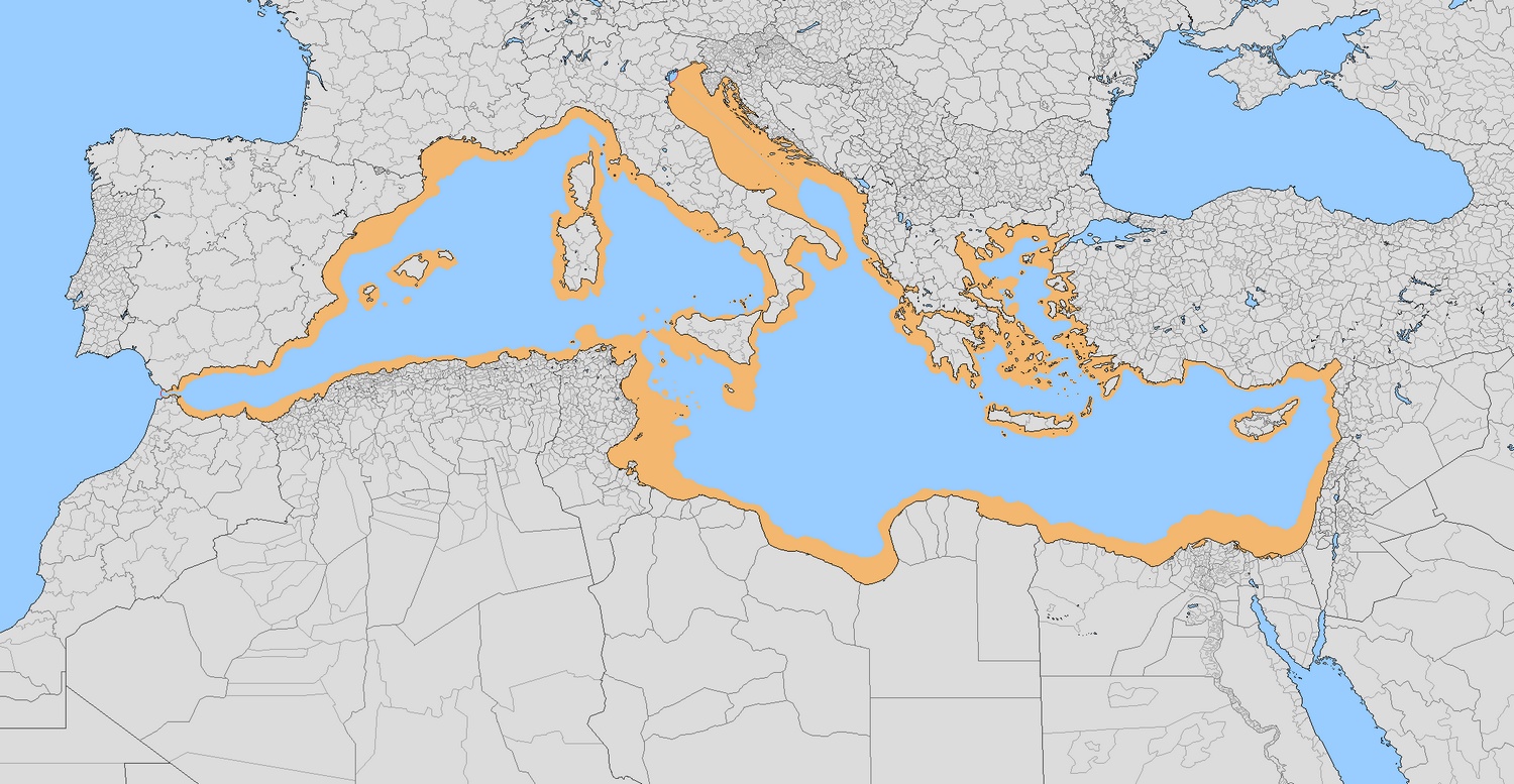
Its primary object was a hydroelectric barrier to be built crossed the Strait of Gibraltar, which would have produced enormous amounts of hydroelectricity (365.000MW) and would have led to the lowering of the surface of the Mediterranean Sea by up to 200 meters (660 ft), opening up significant new territories for settlements.
Sicily and Italy become huge, and the Greek Islands are merged to form one large landmass. More than 240 kilometres (150 miles) of new lands have been reclaimed from the sea all along its former borders more so in Turkey. As it turns out, Soergel expected that this project would add at least 660,000 square kilometres (over 250,000 sq miles) to the base of the neighbouring countries of the Mediterranean, or about the equivalent of the combined landmasses of Germany and Italy.
Land that would have surfaced had Atlantropa happened
The plan offered five huge barriers as well:
The Strait of Gibraltar
The Strait of the Dardanelles
Within Sicily and Tunisia to provide a highway and additionally lower the inner Mediterranean
On the Congo River beneath its Kwah tributary to refill the Mega-Chad basin contributing freshwater to irrigate the Sahara and building a shipping way to the heart of Africa
Suez Canal enlargement and locks to sustain Red Sea connection
The plans didn’t quite work out so well for Sorgel. The Germans have lost WWII, things have taken another way, as Germany’s idea was to capture all of the areas required to build the dams with sufficient materials gained and no permit required.
Below is an imaginary map of Europe if the Nazis still managed to win the Second World War and implement the Atlantropa project.
This map has been created using The Global environmental stratification. The Global environmental stratification (GEnS), based on statistical clustering of bioclimate data (WorldClim). GEnS, consists of 125 strata, which have been aggregated into 18 global environmental zones (labeled A to R) based on the dendrogram. Interactive map >> Via www.vividmaps.com Related posts: - Find cities with similar climate 2050 - How global warming will impact 6000+ cities around the world?
We often talk about record heat , especially in the context of climate change. But on the flip side, our planet also experiences cold so extreme it defies belief—temperatures that can flash-freeze exposed skin and halt life as we know it. These are not just numbers on thermometers; they’re snapshots of how Earth's atmosphere behaves under specific conditions—altitude, wind patterns, and location far from the moderating effects of oceans. The coldest temperature ever recorded on Earth? That title goes to Vostok Station in Antarctica, where scientists measured a bone-cracking −89.2°C (−128.6°F) on July 21, 1983. Located on the East Antarctic Plateau, Vostok is more than 1,000 kilometers from the South Pole and sits atop about 3.7 kilometers (2.3 miles) of ice. It’s isolated, dry, and high—three ingredients that make for perfect deep freeze conditions. The world map below created by VividMaps shows the lowest temperature ever recorded by country. The Coldest Inhabited Place on Earth...
When summer arrives, it brings not only vacation season but also some of the most extreme heat waves across the globe. While many people associate summer with warm, sunny days, some regions endure scorching temperatures that push the limits of human endurance. To put these extremes into perspective, we’ve mapped the highest temperatures ever recorded in countries around the world. The maps below, created by Vivid Maps , illustrate these record-breaking temperatures and the patterns of extreme heat across the globe. The Hottest Temperature on Record According to historical weather data, the highest reliably recorded temperature on Earth is 56.7°C (134°F) , measured in Death Valley, California , on July 10, 1913 . However, an even higher temperature of 58°C (136.4°F) was reportedly recorded in El Azizia, Libya , on September 13, 1922 . While this Libyan record stood for decades, some meteorologists have questioned its accuracy due to inconsistencies in measurement methods at the ti...


This post may contain affiliate links. As an Amazon Associate, I earn from qualifying purchases.
Comments
Post a Comment