The global forest cover comprises over three trillion trees.
Approximately half of these trees (1.3 trillion) are found in the tropics and subtropics, while about one-fourth (0.74 trillion) are in the boreal regions, and one-fifth (0.66 trillion) in temperate regions.
So, how does this distribution look on a country-by-country basis?
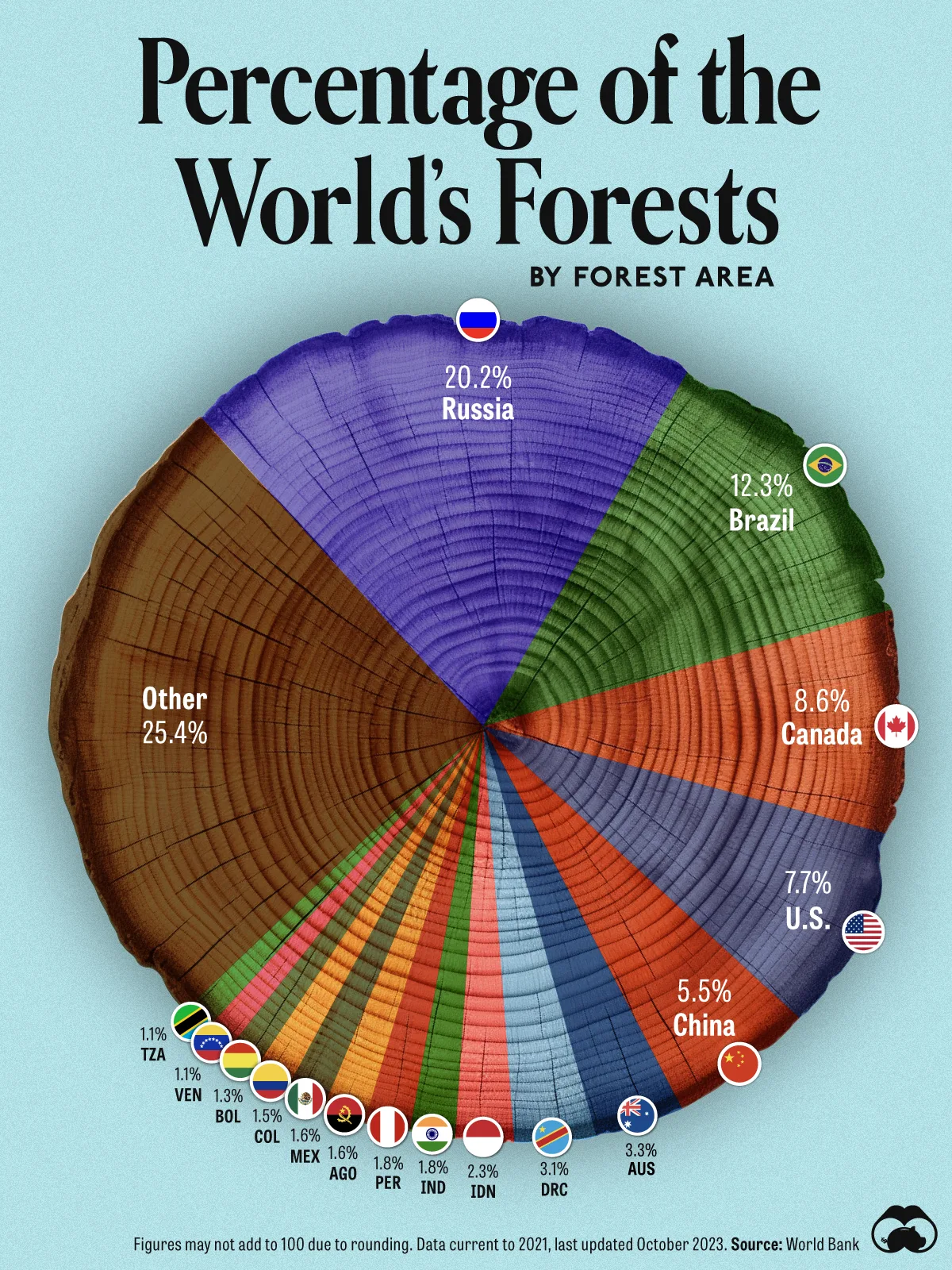
Utilizing data from the World Bank, the VisualCapitalist team illustrated each country's share of the world's total forest area.
Naturally, larger countries typically boast more forested areas, resulting in a higher percentage of the world's forests.
At the forefront of the list, Russia claims over one-fifth of the world's forests, encompassing a vast expanse of 8 million km2, which is slightly less than half of the entire country.
Following closely, Brazil, the fifth-largest and sixth-most populated nation, ranks second with just over 12% of the total forests, covering close to 5 million km2, over 60% of its landmass. Its prominent forest, the Amazon, has encountered significant deforestation, losing 237,000 km2 in five years. The Amazon rainforest is also a substantial part of Peru’s forest cover (ranked 10th on this visualization, with a 1.8% share).
Canada and the U.S. each harbor about 8% of the world's forests, fostering renowned national park systems dedicated to preserving the continent's natural biodiversity.
China secures the fifth spot, contributing 5.5% of the global forest cover. Unlike other nations experiencing forest decline, China has expanded its forest area by 511,807 km2 in 25 years, larger than Thailand's entire landmass. However, critics caution against potential drawbacks, such as promoting monocultures of non-native trees at the expense of native species.
Meanwhile, Australia and the Democratic Republic of Congo (DRC) each claim a 3% share of the world's forests. The Congo Basin, the world's second-largest tropical rainforest, heavily influences the DRC's forest cover and extends across five other countries: Cameroon, Central African Republic, Congo, Equatorial Guinea, and Gabon.
Completing the top 10, Indonesia, India, and Peru each contribute 2% to the global forest coverage.
|
Rank |
Counry |
Forested
area km2 |
% of world's
forests |
|
1 |
Russia |
8,153,116 |
20.10% |
|
2 |
Brazil |
4,953,914 |
12.30% |
|
3 |
Canada |
3,468,911 |
8.60% |
|
4 |
U.S. |
3,097,950 |
7.70% |
|
5 |
China |
2,218,578 |
5.50% |
|
6 |
Australia |
1,340,051 |
3.30% |
|
7 |
DRC |
1,250,539 |
3.10% |
|
8 |
Indonesia |
915,277 |
2.30% |
|
9 |
India |
724,264 |
1.80% |
|
10 |
Peru |
721,575 |
1.80% |
|
11 |
Angola |
660,523 |
1.60% |
|
12 |
Mexico |
655,643 |
1.60% |
|
13 |
Colombia |
589,426 |
1.50% |
|
14 |
Bolivia |
506,208 |
1.30% |
|
15 |
Venezuela |
461,734 |
1.10% |
|
16 |
Tanzania |
452,760 |
1.10% |
|
17 |
Zambia |
446,258 |
1.10% |
|
18 |
Mozambique |
364,976 |
0.90% |
|
19 |
Papua New
Guinea |
358,222 |
0.90% |
|
20 |
Argentina |
284,637 |
0.70% |
Countries with abundant forest cover and smaller populations also have higher forest area per capita.
|
Rank |
Country |
Sq. meters
per capita |
|
1 |
French
Guiana |
301,716 |
|
2 |
Suriname |
260,815 |
|
3 |
Guyana |
216,259 |
|
4 |
Gabon |
109,335 |
|
5 |
Niue |
95,773 |
|
6 |
Canada |
94,921 |
|
7 |
Russia |
56,022 |
|
8 |
Australia |
50,982 |
|
9 |
Bolivia |
47,384 |
|
10 |
Central
African Republic |
44,306 |
|
11 |
Botswana |
44,281 |
|
12 |
Congo |
41,984 |
|
13 |
Finland |
40,337 |
|
14 |
Mongolia |
39,916 |
|
15 |
Papua New
Guinea |
36,812 |
|
16 |
Bhutan |
36,697 |
|
17 |
Belize |
36,197 |
|
18 |
Solomon
Islands |
33,774 |
|
19 |
New
Caledonia |
29,506 |
|
20 |
Namibia |
28,634 |

This post may contain affiliate links. As an Amazon Associate, I earn from qualifying purchases.
Comments
Post a Comment