Shoreline degradation and Coastal population

Shoreline degradation refers to the deterioration or erosion of coastal areas, including beaches, dunes, and cliffs. It is primarily caused by natural processes such as wave action, storms, and tides, but human activities can significantly exacerbate the problem. Human-induced factors contributing to shoreline degradation include coastal development, sand mining, pollution, climate change, and unsustainable coastal management practices.

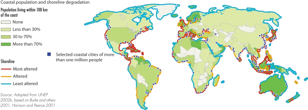
The map below crated by a non-profit environmental communications GRID-Arendal shows coastal population and shoreline degradation.

Shoreline degradation

Population size can have a significant impact on coastal degradation. Here are a few ways in which population size can affect coastal degradation:

  • Urbanization and Infrastructure: As the population increases, there is a greater demand for coastal areas for housing, tourism, and industry. This leads to the construction of coastal infrastructure such as buildings, roads, ports, and harbors. The alteration of natural coastal features, including wetlands and mangroves, and the construction of hard structures like seawalls and jetties can disrupt natural sediment flows, exacerbating erosion and altering the natural balance of coastal ecosystems.
  • Increased Pollution: Higher population densities along the coast can result in increased pollution from sewage, industrial discharges, and runoff from urban areas. These pollutants can degrade water quality, harm marine life, and contribute to the degradation of coastal ecosystems.
  • Overfishing and Habitat Destruction: Growing populations can put pressure on coastal fisheries, leading to overfishing and the destruction of critical habitats such as coral reefs, seagrass beds, and mangrove forests. These habitats provide important protection against coastal erosion by absorbing wave energy and stabilizing sediments.
  • Climate Change: While population size itself may not directly cause climate change, the increased emission of greenhouse gases associated with larger populations contributes to global warming. Rising sea levels, increased storm intensity, and altered weather patterns associated with climate change can accelerate coastal erosion and destabilize shorelines.
  • Resource Extraction: Growing populations demand more resources, including sand for construction and coastal nourishment. Unsustainable sand mining practices can deplete beach and dune systems, leading to accelerated erosion and increased vulnerability to storms.
This post may contain affiliate links. As an Amazon Associate, I earn from qualifying purchases.


Comments

Popular posts from this blog

Find cities with similar climate

This map has been created using The Global environmental stratification. The Global environmental stratification (GEnS), based on statistical clustering of bioclimate data (WorldClim). GEnS, consists of 125 strata, which have been aggregated into 18 global environmental zones (labeled A to R) based on the dendrogram. Interactive map >> Via www.vividmaps.com Related posts: -  Find cities with similar climate 2050 -  How global warming will impact 6000+ cities around the world?

Moose population in North America

The moose ( Alces alces ) is the largest member of the deer family, characterized by its massive size, long legs, and distinctive broad, palmate antlers found in males. They have a dark brown or black coat and a humped shoulder. Moose are primarily found in the boreal and mixed deciduous forests of North America, Europe, and Asia. They are solitary animals, often found near bodies of water, and are herbivores that feed on leaves, bark, twigs, and aquatic vegetation. Despite their size, moose are strong swimmers and can run up to 35 miles per hour. The moose population in North America is shrinking swiftly. This decrease has been correlated to the opening of roadways and landscapes into this animal's north range.   In North America, the moose range includes almost all of Canada and Alaska, the northern part of New England and New York, the upper Rocky Mountains, northern Minnesota and Wisconsin, Michigan's Upper Peninsula, and Isle Royale.    In 2014-2015, the North American moo

Map of Fox Species Distribution

Foxes are small to medium-sized members of the Canidae family, which also includes wolves, dogs, and other related animals. There are about 37 species of foxes distributed around the world, and they inhabit a wide range of environments, from forests and grasslands to deserts and urban areas. Below is the map of fox species distribution  created by Reddit user isaacSW Here are some of the most well-known fox species and their distribution: Red Fox ( Vulpes vulpes ): The red fox is one of the most widely distributed fox species and is found in North America, Europe, Asia, and parts of North Africa. They are adaptable and can live in a variety of habitats, including forests, grasslands, and urban areas. Arctic Fox ( Vulpes lagopus ): The Arctic fox is found in the Arctic regions of North America, Europe, and Asia. They have adaptations that help them survive in cold climates, such as a thick coat that changes color with the seasons. Gray Fox ( Urocyon cinereoargenteus ): The gray fox