
The diversity of trees in the United States mapped

According to the US Forest Service paper, about 640 different species of trees in the US, 186 of which are endemic.

Maps below present the entire tree species richness and endemic tree species in the US. These maps are based on data presented in Atlas of United States Trees.

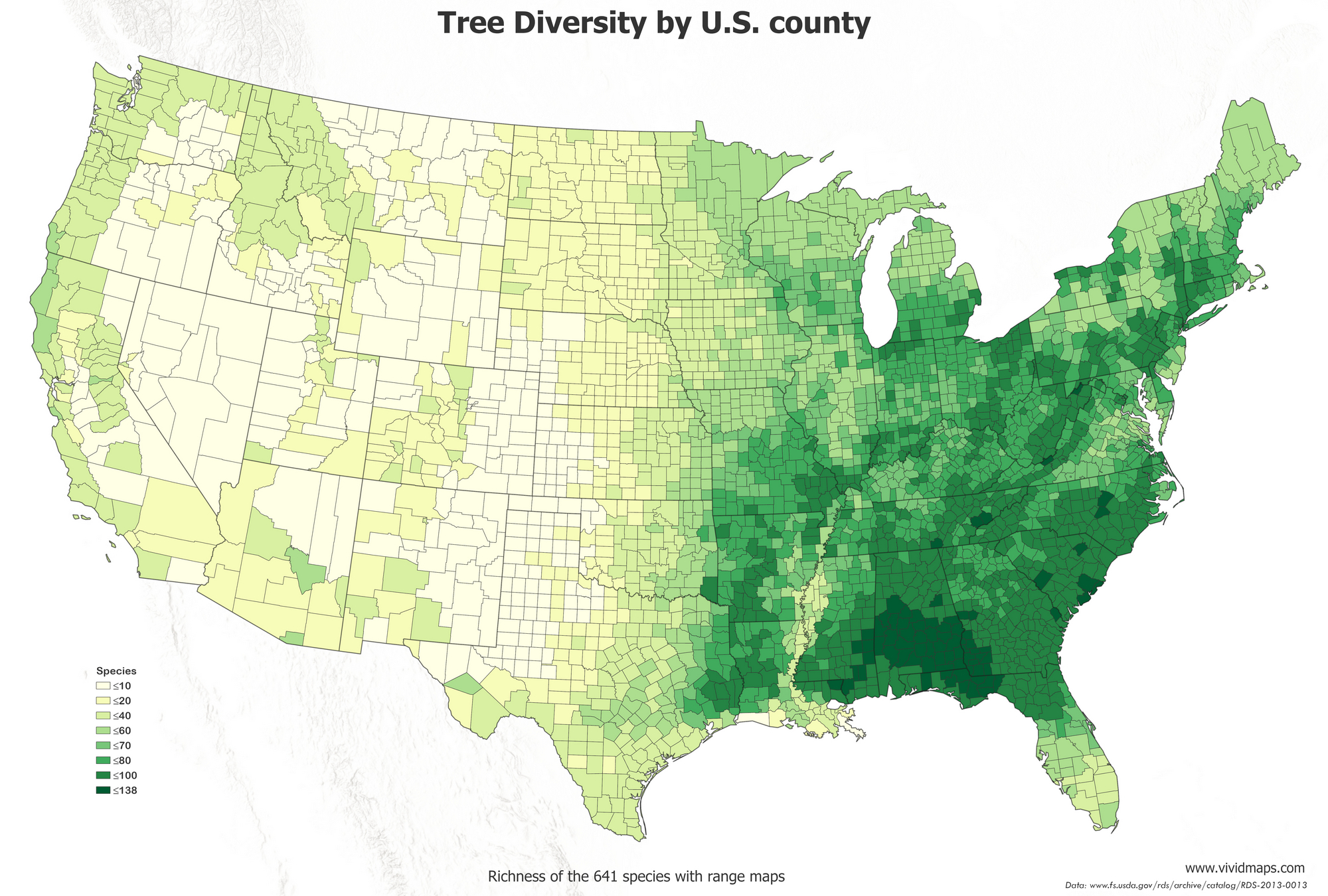
Maps of tree species richness of the United States

The southeastern US has the greatest species diversity of trees.

The atlas of tree diversity in the U.S.

The most notable quantity of species of trees grows in the US  states of Mississippi, Alabama, Georgia, and Florida.

Liberty County in Florida has the highest tree species richness (138 species) in the US.

Map of the tree diversity by U.S. county
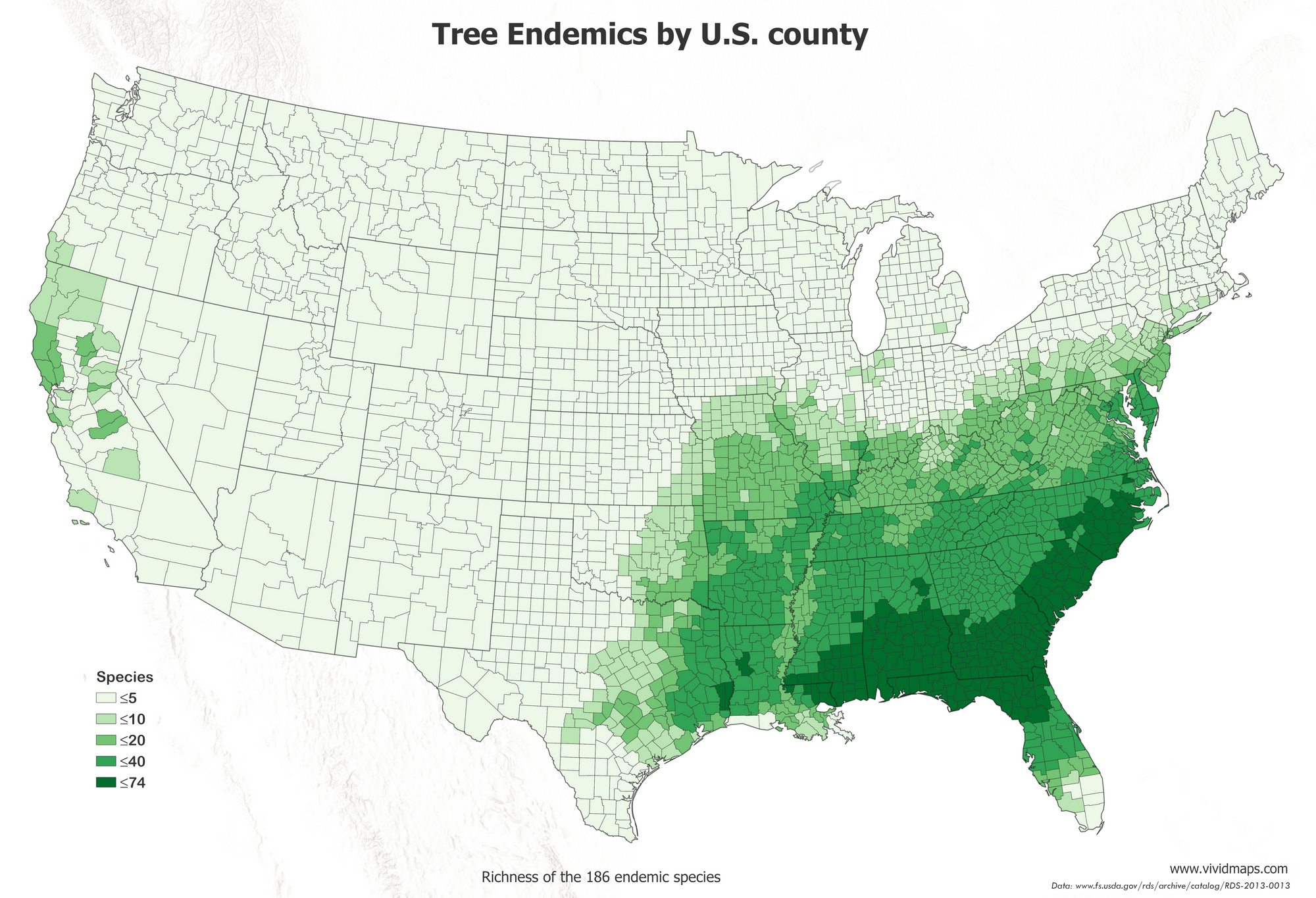
Maps of tree endemic species richness of the U.S.

The southeastern US also has the highest endemicity of tree species.

Map of endemic tree species in the U.S.

The most significant number of endemic tree species also grow in Liberty County (Florida).

Map of the Tree endemics by U.S. county

Top 10 most common tree species in the U.S.
  1. Red Maple or (Acer rubrum)
  2. Loblolly Pine or (Pinus taeda)
  3. Loblolly Pine or (Pinus taeda)
  4. Douglas Fir or (Pseudotsuga menziesii)
  5. Quaking Aspen or (Populus tremuloides)
  6. Sugar Maple or (Acer saccharum)
  7. Balsam Fir (Abies balsamea)
  8. Flowering Dogwood (Cornus florida)
  9. Lodgepole Pine (Pinus contorta)
  10. White Oak (Quercus alba)
Information about all tree species of the United States you can find here.

This post may contain affiliate links. As an Amazon Associate, I earn from qualifying purchases.


Comments

Popular posts from this blog

Find cities with similar climate

This map has been created using The Global environmental stratification. The Global environmental stratification (GEnS), based on statistical clustering of bioclimate data (WorldClim). GEnS, consists of 125 strata, which have been aggregated into 18 global environmental zones (labeled A to R) based on the dendrogram. Interactive map >> Via www.vividmaps.com Related posts: -  Find cities with similar climate 2050 -  How global warming will impact 6000+ cities around the world?

The Appalachian Mountains, the Scottish Highlands, and the Atlas Mounts in Africa were the same mountain range

The Central Pangean Mountains was a prominent mountain ridge in the central part of the supercontinent Pangaea that extends across the continent from northeast to southwest through the Carboniferous , Permian Triassic periods. The mountains were formed due to a collision within the supercontinents Gondwana and Laurussia during the creation of Pangaea. It was comparable to the present Himalayas at its highest peak during the start of the Permian period. It isn’t easy to assume now that once upon a time that the Scottish Highlands, The Appalachian Mountains, the Ouachita Mountain Range, and the Atlas Mountains in northwestern Africa are the same mountains , once connected as the Central Pangean Mountains.

Moose population in North America

The moose population in North America is shrinking swiftly. This decrease has been correlated to the opening of roadways and landscapes into this animal's north range.   In North America, the moose range includes almost all of Canada and Alaska, the northern part of New England and New York, the upper Rocky Mountains, northern Minnesota and Wisconsin, Michigan's Upper Peninsula, and Isle Royale.    In 2014-2015, the North American moose population was measured at around one million animals. The most abundant moose population (about 700,000) lives in Canada. About 300 000 moose remains in nineteen U.S. states Alaska, Colorado, Connecticut, Idaho, Maine, Massachusetts, Minnesota, Montana, Michigan, Nevada, New Hampshire, New York, North Dakota, Oregon, Utah, Vermont, Washington, Wisconsin, and Wyoming. The largest moose specimens are found in Alaska 200 thousand moose. Below the map shows the size of US states scaled by the moose population.     Via www.vividmaps.com