Atlantropa was a huge construction and colonization idea produced by the German architect Herman Sörgel in the 1920s.
He intended to connect the continents of Europe and Africa throughout the partial evaporation of the Mediterranean Sea (drain 1/5 of the Mediterranean sea), allowing millions of Europeans to get a new life in what would become the Eurafrican supercontinent (Atlantropa). The new supercontinent would provide food for 150 million people.
The idea was caused by the then-new understanding of the Messinian salinity crisis, a pan-Mediterranean geological event that took place 5- 6 million years ago.
The basin of the Mediterranean Sea is hydrologically deficient, which means that it loses water by evaporation rather than gains by the supplying of rivers.
Its primary object was a hydroelectric barrier to be built crossed the Strait of Gibraltar, which would have produced enormous amounts of hydroelectricity (365.000MW) and would have led to the lowering of the surface of the Mediterranean Sea by up to 200 meters (660 ft), opening up significant new territories for settlements.
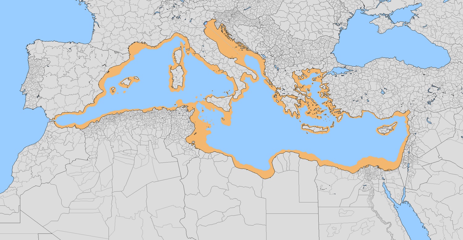
Sicily and Italy become huge, and the Greek Islands are merged to form one large landmass. More than 240 kilometres (150 miles) of new lands have been reclaimed from the sea all along its former borders more so in Turkey. As it turns out, Soergel expected that this project would add at least 660,000 square kilometres (over 250,000 sq miles) to the base of the neighbouring countries of the Mediterranean, or about the equivalent of the combined landmasses of Germany and Italy.
Land that would have surfaced had Atlantropa happened
The plan offered five huge barriers as well:
The Strait of Gibraltar
The Strait of the Dardanelles
Within Sicily and Tunisia to provide a highway and additionally lower the inner Mediterranean
On the Congo River beneath its Kwah tributary to refill the Mega-Chad basin contributing freshwater to irrigate the Sahara and building a shipping way to the heart of Africa
Suez Canal enlargement and locks to sustain Red Sea connection
The plans didn’t quite work out so well for Sorgel. The Germans have lost WWII, things have taken another way, as Germany’s idea was to capture all of the areas required to build the dams with sufficient materials gained and no permit required.
Below is an imaginary map of Europe if the Nazis still managed to win the Second World War and implement the Atlantropa project.
Foxes are small to medium-sized members of the Canidae family, which also includes wolves, dogs, and other related animals. There are about 37 species of foxes distributed around the world, and they inhabit a wide range of environments, from forests and grasslands to deserts and urban areas. Below is the map of fox species distribution created by Reddit user isaacSW Here are some of the most well-known fox species and their distribution: Red Fox ( Vulpes vulpes ): The red fox is one of the most widely distributed fox species and is found in North America, Europe, Asia, and parts of North Africa. They are adaptable and can live in a variety of habitats, including forests, grasslands, and urban areas. Arctic Fox ( Vulpes lagopus ): The Arctic fox is found in the Arctic regions of North America, Europe, and Asia. They have adaptations that help them survive in cold climates, such as a thick coat that changes color with the seasons. Gray Fox ( Urocyon cinereoargenteus ): The gray ...
Plastic: the unwelcome house guest at nearly every corner of our lives — from shopping bags to footwear, coffee cups to car parts. And yet, discarded, plastic doesn't just evaporate into thin air. No, it lingers. For decades. Even centuries. According to statistics presented by Visual Capitalist , plastic daily consumer goods can break down between 20 and 600 years, depending on the composition used, how they were created, and natural elements like water and sunlight they are exposed to. Let's go deeper into why plastic takes so long to break down — and what horrid messes it leaves behind in the process. Why Plastic Isn't "Natural" — and Why That's a Problem Plastic does not naturally exist. It's a product made from petroleum and natural gas. Its long, tough carbon bonds differ from anything naturally found in ecosystems, making it extremely resistant to microbial breakdown. When we toss a plastic bottle or bag away, it's not a matter of if it will s...
Located in southwestern Pennsylvania's woods, Fallingwater is not a house, but a powerful conversation between nature and architecture. Completed in 1935 by Frank Lloyd Wright for the Kaufmanns, it's one of the only buildings that truly does seem alive—as if it grew directly out of the rock. What is so revolutionary about Fallingwater isn't its appearance—it's Wright's philosophy of organic architecture: the idea that houses are there to harmonize with nature, not dominate it. The house was actually constructed into the land, resting directly above a waterfall on Bear Run. Instead of looking out over the waterfall, Wright built the waterfall into the house, and the sound of running water is therefore a constant companion. Crafted From the Land, For the Land The materials used to build Fallingwater tell their own story. The stone was quarried on-site. Local craftsmen helped shape every contour. The horizontal lines of the cantilevered terraces echo the layered rock...


This post may contain affiliate links. As an Amazon Associate, I earn from qualifying purchases.
Comments
Post a Comment