The last glacial period, commonly known as the Last Ice Age, was a remarkable era in Earth's history that left an indelible mark on the landscapes of Europe. This dramatic chapter unfolded from around 115,000 to 11,700 years ago, sculpting the continent we know today.
 www.stb806.de
 www.deviantart.com
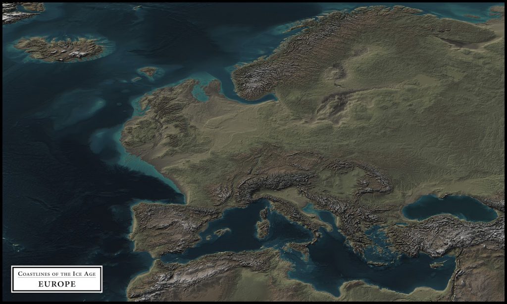
During the peak of the Last Ice Age, vast sheets of ice blanketed large swaths of Europe. Thick glaciers entirely covered countries like Iceland, Ireland, Norway, Sweden, Finland, Estonia, Latvia, and for thousands of years. The Scandinavian and British ice sheet extended as far south as northern Poland and Germany, while also engulfing almost all of Denmark. To the east, the ice crept into the territory of Russia, reaching about 300 km west of Moscow, and even touched parts of northern Belarus.
In the west, the British Isles were largely entombed in ice, with only a relatively small ice-free zone remaining in the south of the United Kingdom. The sheer scale of these glaciers is staggering—at the height of the Last Ice Age, the world's glaciers covered an area of around 44.4 million square kilometers, nearly three times more than the 14.9 million square kilometers they occupy today.
www.stb806.de The legacy of this glacial epoch is etched into the European landscape, leaving behind a distinctive geological record. Erratic boulders, till, drumlins, eskers, fjords, kettle lakes, and moraines are all tell-tale signs of the glaciers' passage, providing valuable clues for reconstructing the ice coverage during this remarkable period.
Interestingly, the source populations of Paleolithic humans managed to survive the Last Ice Age by inhabiting sparsely wooded areas and dispersing through regions of high primary productivity, carefully avoiding the dense forest cover that emerged in other parts of Europe. This adaptive resilience allowed our ancestors to weather the climatic challenges posed by the glacial advance and retreat.
As the glaciers grew, the volume of water locked in ice sheets caused global sea levels to drop by approximately 120 meters (around 394 feet). This significant decrease in sea level expanded the land area of Europe considerably. Vast stretches of what are now underwater regions, such as the North Sea and the English Channel, were exposed, creating a continuous landmass that connected the British Isles to mainland Europe. Large parts of the continental shelf that are now submerged were habitable land, supporting wildlife and human populations.
www.deviantart.com Today, as we grapple with the pressing issue of climate change, the lessons of the Last Ice Age serve as a powerful reminder of the profound impact that large-scale environmental shifts can have on the natural world and human societies. By understanding the past, we can better prepare for the challenges of the future and ensure the continued resilience of our planet and its inhabitants.
For those interested in learning more about the Last Ice Age and its impact, here are some recommended books and documentaries available on Amazon:
Books:
Books:
- "The Ice Age: A Very Short Introduction" by Jamie Woodward
- "Europe: A Natural History" by Tim Flannery.
Documentaries:
This post may contain affiliate links. As an Amazon Associate, I earn from qualifying purchases.